Puerto Vallarta, Mexico – NOAA says the first storm Pacific hurricane season 2025 may form tonight off Mexico’s southern coast as showers and thunderstorms organize in favorable conditions.
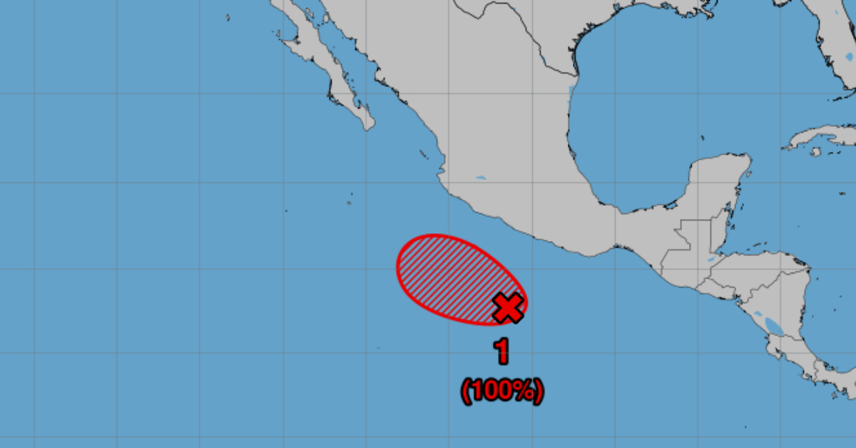
The National Oceanic and Atmospheric Administration (NOAA) issued its first formal alert on Tuesday evening for what could become the inaugural named storm of the Eastern Pacific’s 2025 hurricane season. Satellite imagery shows showers and thunderstorms becoming better organized near a broad area of low pressure located several hundred miles south of the coast of southern Mexico. While the system still lacks a well-defined circulation, environmental conditions are favorable for further development, and a tropical depression or tropical storm is expected to form tonight, NOAA forecasters said.
At the time of the advisory, the disturbance lay roughly 300 miles south-southwest of Puerto Ángel, Oaxaca, moving west-northwest at about 10 mph. Sea surface temperatures in the region hover near 29 °C (84 °F), well above the threshold typically needed to fuel tropical cyclones, while upper-level winds remain light, limiting disruptive wind shear. These factors combine to give the system a high—some models suggest greater than 70%—chance of achieving tropical depression status within the next 24 hours.
NOAA’s Tropical Prediction Center noted that once a closed circulation develops and sustained winds reach 39 mph, the system would graduate to a named storm, likely “Andres,” the first name on this year’s Eastern Pacific list. The agency will issue its next formal tropical weather outlook at 8 p.m. CDT tonight, with hourly updates available on the NOAA website and via the National Hurricane Center’s social channels.
Although the low-pressure area currently poses no immediate threat to land, forecasters caution that heavy rains, gusty winds, and elevated surf could begin affecting coastal areas of Oaxaca and Guerrero by mid-week. Small craft advisories may become necessary as seas build to 10–15 feet over open water. Fishermen and recreational boaters are urged to monitor local marine forecasts and exercise caution.
Historically, the Eastern Pacific hurricane season runs from May 15 through November 30. Early-season storms are not uncommon but often remain far from Mexico’s coast. An early formation can hint at an active season ahead—NOAA’s spring outlook predicted an above-average year, calling for 15–18 named storms and 7–9 hurricanes. Should Andres form as expected, it will mark the first of what could be a busy season for communities along Mexico’s Pacific shores.
Residents in low-lying coastal communities should stay alert to any tropical storm watches or warnings that Mexican meteorological services may issue. Even without a direct landfall, heavy rainfall can trigger flash floods and mudslides in the region’s rugged terrain. Emergency management officials recommend reviewing evacuation routes, securing outdoor furniture, and ensuring emergency supplies are on hand.
Mariners operating off Mexico’s southern coast should heed NOAA’s guidance. As the system organizes, wind speeds can spike with little notice, making small vessels especially vulnerable. NOAA’s latest update reminds all seafarers to file a voyage plan with authorities and maintain regular contact with coastal stations.
Looking ahead, the disturbance will track west-northwest over open water. If upper-level wind patterns remain favorable, it could intensify into a hurricane by mid-week. However, a turn northward cannot be ruled out, which would bring the system closer to Mexico’s shoreline. Forecasters emphasize that the exact path and intensity remain uncertain until a well-defined center forms.
The public can follow real-time updates through the National Hurricane Center’s online portal, NOAA Weather Radio, and official social media feeds. NOAA reminds everyone that even tropical depressions warrant attention, as they can quickly strengthen under the right conditions.
Puerto Vallarta, Mexico - NOAA says the first storm Pacific hurricane season 2025 may form tonight off Mexico’s southern coast as showers and thunderstorms organize in favorable conditions.


